Supported Devices
Delorme
Device Summary
The Delorme device is an advanced satellite communication and tracking solution designed for reliable performance in remote and challenging environments. Integrated with the GSatTrack platform, the Delorme device provides users with real-time tracking, messaging, and emergency services capabilities. Known for its durability and ease of use, it is ideal for a variety of applications across numerous industries.
InReach
Message sizes
Position report: 13 bytes OR 17 bytes. This is decided by the firmware based on movement and is not controllable. For airtime usage, always use the larger 17-byte figure for calculations.
Free-form text messages: 1 byte per character with a 160-byte maximum
DeLorme position reports per plan
| Plan Name | Position reports |
|---|---|
| 1.5K | 88 |
| 3K | 176 |
| 12K | 705 |
| 30K | 1764 |
Adding devices
All Assets can be added to the portal with the Add Item tool (+).
To add an InReach device, select Garmin as the Manufacturer from the drop-down list, and then have the device ID ready. Users can set any additional attributes they wish to set at any time during the Add Asset flow, or by opening the Asset once it has been added and selecting Edit Asset.
Enterprise Customers
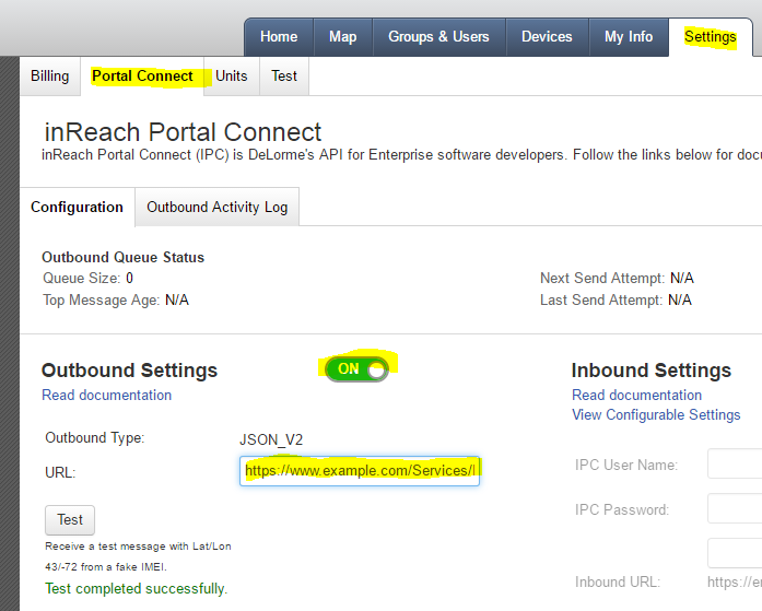
DeLorme Enterprise customers must configure the InReach Portal Connect (IPC) Outbound option on their Enterprise account for InReach messages to be relayed to the portal. Ensure that the IPC service is enabled (checkbox) and set the IPC Outbound to: https://www.gsattrack.com/Services/InReach.svc/Events
Additionally, ensure that you have turned on “Share Map View” so that your asset will be visible in the portal.
After making the necessary changes, make sure you hit the “Save” button at the bottom of the page.
Additional Information
Key Features
- Global Satellite Coverage: Provides tracking and communication capabilities anywhere in the world, ensuring connectivity even in the most remote locations.
- Two-Way Messaging: Allows users to send and receive messages, enhancing communication between remote users and their teams.
- Emergency SOS Functionality: Features an SOS button that sends an emergency alert with the user’s location to predefined contacts or emergency services.
- Durable and Rugged Design: Built to withstand harsh environmental conditions, ensuring reliable operation in outdoor and rugged settings.
- Integrated GPS Tracking: Offers accurate location tracking and navigation features, allowing users to monitor their movements in real-time.
- User-Friendly Interface: Designed for ease of use, enabling quick setup and straightforward operation for users of all skill levels.
Use Cases
- Outdoor Adventures: Popular among hikers, climbers, and outdoor enthusiasts for tracking routes, sharing locations, and ensuring safety in remote areas.
- Search and Rescue Operations: Utilized by rescue teams to coordinate efforts and track personnel in challenging terrains, enhancing the efficiency of emergency response.
- Field Research: Employed by scientists and researchers in remote locations to collect data, communicate findings, and ensure safety during fieldwork.
- Marine Tracking: Used by boaters and fishermen to maintain communication and track their positions while out on the water, improving safety and navigation.
- Fleet Tracking: Assists logistics and transportation companies in monitoring their vehicles, optimizing routes, and improving operational efficiency through real-time data.
- Wildlife Conservation: Helps conservationists track and monitor wildlife movements, aiding in the study and protection of endangered species in their natural habitats.