Supported Devices
Delorme
Device Summary
The Delorme device is a satellite communication and tracking unit for remote, challenging environments. Integrated with GSatTrack, it provides real-time tracking, two-way messaging, and emergency SOS services.
InReach
Message sizes
Position report: 13 bytes OR 17 bytes. This is decided by the firmware based on movement and is not controllable. For airtime usage, always use the larger 17-byte figure for calculations.
Free-form text messages: 1 byte per character with a 160-byte maximum
DeLorme position reports per plan
| Plan Name | Position reports |
|---|---|
| 1.5K | 88 |
| 3K | 176 |
| 12K | 705 |
| 30K | 1764 |
Adding devices
All Assets can be added to the portal with the Add Item tool (+).
To add an InReach device, select Garmin as the Manufacturer from the drop-down list, and then have the device ID ready. Users can set any additional attributes they wish to set at any time during the Add Asset flow, or by opening the Asset once it has been added and selecting Edit Asset.
Enterprise Customers
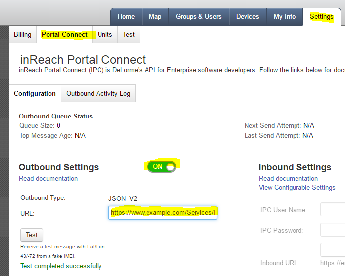
DeLorme Enterprise customers must configure the InReach Portal Connect (IPC) Outbound option on their Enterprise account for InReach messages to be relayed to the portal. Ensure that the IPC service is enabled (checkbox) and set the IPC Outbound to: https://www.gsattrack.com/Services/InReach.svc/Events
Additionally, ensure that you have turned on “Share Map View” so that your asset will be visible in the portal.
After making the necessary changes, make sure you hit the “Save” button at the bottom of the page.
Additional Information
Key Features
- Global Satellite Coverage — tracking and communication anywhere in the world, including remote locations.
- Two-Way Messaging — send and receive messages between remote users and their teams.
- Emergency SOS — SOS button sends an alert with the user's location to predefined contacts or emergency services.
- Durable and Rugged Design — built to withstand harsh outdoor environmental conditions.
- Integrated GPS Tracking — accurate real-time location tracking and navigation.
Use Cases
- Outdoor Adventures — hikers, climbers, and outdoor enthusiasts track routes and share locations for safety in remote areas.
- Search and Rescue — rescue teams coordinate efforts and track personnel across challenging terrain.
- Field Research — scientists in remote locations collect data and communicate during fieldwork.
- Marine Tracking — boaters and fishermen maintain communication and track positions on the water.